Paikkatietohakemisto
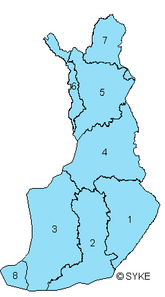
Vesienhoitoalueet
EU:n vesipolitiikan puitedirektiivin mukaiset vesienhoitoalueet Suomessa.
Suomessa vesipuitedirektiivi on toimeenpantu keskeisiltä osin lailla vesienhoidon järjestämisestä eli vesienhoitolailla (N:o 1299, annettu 30.12.2004, voimaantulo 31.12.2004) sekä valtioneuvoston asetuksella vesienhoitoalueista (N:o 1303, annettu 30.12.2004, voimaantulo 1.1.2005). Suomen vesienhoitoalueet ovat 1) Kymijoen-Suomenlahden vesienhoitoalue, 2) Kokemäenjoen-Saaristomeren-Selkämeren vesienhoitoalue, 3) Oulujoen-Iijoen vesienhoitoalue sekä 4) Kemijoen vesienhoitoalue. Lisäksi Ruotsin kanssa muodostetaan kansainvälinen vesienhoitoalue Tornionjoen vesistöalueelle ja Norjan kanssa Tenon, Näätämöjoen ja Paatsjoen vesistöalueille. Vesienhoitolain täytäntöönpanon tehtävistä huolehtivat Elinkeino-, liikenne- ja ympäristökeskukset. Ahvenanmaan maakunta muodostaa oman vesienhoitoalueensa ja siellä vesipuitedirektiivin toimeenpano pohjautuu Ahvenanmaan maakunnan omaan lainsäädäntöön. Aineisto kuuluu SYKEn avoimiin aineistoihin (CC BY 4.0).
Aineistosta on julkaistu INSPIRE-tietotuote.
Käyttötarkoitus:
Vesienhoitoalueiden sijainnin esittäminen.
Lisätietoja:
https://geoportal.ymparisto.fi/meta/julkinen/dokumentit/vesienhoitoalueet.pdf
The River Basin District dataset includes Finnish River Basin Districts in accordance with the EU's Water Framework directive (WFD). WFD has been implemented in Finland through the Act on Water Resources Management (No 1299/2004 given in Helsinki on 30 December 2004) and through the Government Decree on Water Resources Management Regions (Nro 1303/2004, issued in Helsinki 30 December 2004). Finnish river basin districts are 1) the river basin district of river Vuoksi, 2) the river basin district of the river Kymijoki-Gulf of Finland, 3) the river basin district of the river Kokemäenjoki-Archipelago Sea- Bothnian Sea, 4) the river basin district f the river Oulujoki-the river Iijoki and 5) the river basin district of the river Kemijoki. Beside these, an international river basin districts have been formed with Sweden in the river basin of the river Tornionjoki, and with Norway, in the river basins of the river Teno, the river Näätämönjoki and the river Paatsjoki.
Execution of measures for implementing the Act on Water Resources Management is a responsibility of the local Centres for Economic Development, Transport and the Environment. The Åland Islands form an own river basin district and the implementation WFD is based on the legislation of Åland's government.
http://www.ymparisto.fi/default.asp?node=9130&la
This Syke’s dataset can be used according to open data license (CC BY 4.0).
INSPIRE compatible dataset has been published.
Simple
- Date (Publication)
- 2005-01-01
- Point of contact
-
Organisation name Individual name Electronic mail address Role Suomen ympäristökeskus
Owner
-
INSPIRE priority data set
-
SYKE resource classification
-
-
Paikkatietoaineisto
-
- Keywords
-
-
INSPIRE-tietotuote
-
- Keywords
-
-
Ympäristön seuranta
-
sisävedet ja meret
-
-
High-value dataset categories
-
-
Maan havainnointi ja ympäristö
-
-
EU legislation
-
-
Arvokkaat tietoaineistot
-
INSPIRE
-
- Use constraints
- Other restrictions
- Other constraints
-
Creative Commons Nimeä 4.0 Kansainvälinen http://www.syke.fi/fi-FI/Avoin_tieto/Kayttolupa_ja_vastuut
Lähde: Syke
- Access constraints
- Other restrictions
- Other constraints
- no limitations
- Spatial representation type
- Vector
- Denominator
- 50000
- Language
- Finnish
- Topic category
-
- Environment
))
- Distribution format
-
Name Version ESRI shapefile
3.x
GML
3.2.1
OGC WMS
1.3.0
OGC WFS
2.0.0.
- OnLine resource
-
Protocol Linkage Name https://wwwd3.ymparisto.fi/d3/gis_data/spesific/vha.zip Syken Avoin tieto -palvelu
http://wwwd3.ymparisto.fi/d3/INSPIREAtom/AM_vesienhoitoalueet.xml Syken INSPIRE ATOM-syöte
https://paikkatiedot.ymparisto.fi/geoserver/inspire_am1/wms?service=WMS&version=1.3.0&request=GetCapabilities AlueidenHallintaJaRajoitukset1 INSPIRE WMS -katselupalvelu
https://paikkatiedot.ymparisto.fi/geoserver/inspire_am1/wfs AlueidenHallintaJaRajoitukset1 WMS-latauspalvelu
- Hierarchy level
- Dataset
Conformance result
- Date (Publication)
- 2010-12-08
- Explanation
-
Tietotuotemäärittelyt Inspire-direktiivin mukaisten paikkatietotuotteiden osalta.
- Pass
- Yes
- Statement
-
Vesienhoitoalue muodostuu yhdestä tai useammasta vesistöalueesta. Aineisto on tuotettu vesistöaluerajoista, jotka on rajattu mittakaavassa 1: 50 000.
The dataset has been produced from the main river basin boundaries, outlined on a scale 1:50000.
- File identifier
- {6AF42DE4-EB9A-4568-9E6C-90BEF19673D0} XML
- Metadata language
- Finnish
- Character set
- UTF8
- Hierarchy level
- Dataset
- Date stamp
- 2024-05-20
- Metadata standard name
-
ISO 19115
- Metadata standard version
-
2003/Cor.1:2006
- Metadata author
-
Organisation name Individual name Electronic mail address Role Suomen ympäristökeskus
Point of contact